We spoke with Fabien Durand, Alberto Azevedo and Alice Fassoni to learn more about WORSICA, one of the thematic services, and its contribution to the mapping of the Amazon river estuary.
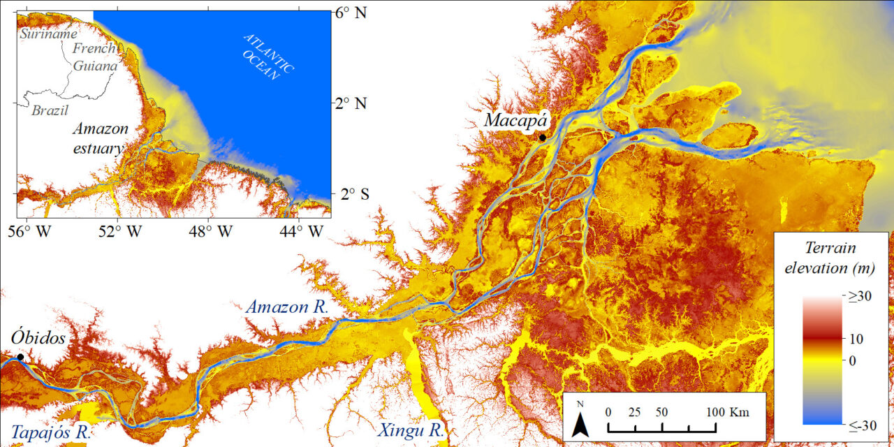
In an international collaboration, the laboratories LEGOS (France), Geociências/UnB (Brazil), and LNEC (Portugal) have developed a high resolution (30 m) mapping of the topography of the Amazon River estuary using satellite images and nautical charts (see figure below). The atlas was produced in the context and with the financial support of the EOSC-Synergy project (WORSICA thematic service) and can be downloaded here. In addition, the article “Comprehensive bathymetry and intertidal topography of the Amazon estuary”, with the description of the methodology, can be found by clicking here.
Remote sensing data on flood extent were used to estimate the topography of the banks and floodplains of the Amazon estuary. The riverbed was estimated from 19 nautical charts digitized by the Brazilian Navy. In the figure below, the blue-yellow color bar indicates the areas permanently submerged – the riverbed – the yellow-orange color bar indicates the floodable areas – margins and floodable lakes – and the red indicates the areas constantly emerging.
It was a great challenge to build the database for the Amazon estuary as it is the longest estuary in the world (~1000 km) and has the largest outflow exported to the ocean. For this same reason, it is also an excellent case study to be tested by the SCHISM hydrodynamic model using the OPENCoastS service.
The WORSICA service will be updated to integrate the topography mapping, previously described, through a liaison with the OPENCoastS service and Pekel’s Global Surface Water maps. This integration will be available to the scientific community at the end of the EOSC-Synergy project via the WORSICA portal.
OPENCoastS is also a service listed in EOSC’s marketplace catalog and was developed in the scope of the EOSC-hub project. The connection between WORSICA and OPENCoastS will serve to determine the water levels for a particular location, observed in the satellite images, considering the results of the hydrodynamic numerical modeling simulations provided by the OPENCoastS service.
Read more about the WORSICA and other thematic services: https://www.eosc-synergy.eu/home/developing-capability